
Fail:1956 Atlantic hurricane season map - 2.png

Size of this preview: 798 × 599 pixels. Other resolutions: 320 × 240 pixels | 639 × 480 pixels | 1,023 × 768 pixels | 1,280 × 962 pixels | 2,078 × 1,561 pixels.
Bikpela piksa (2,078 × 1,561 pixels, file size: 467 KB, MIME type: image/png)
Liklik toksave bilong senis
| Description |
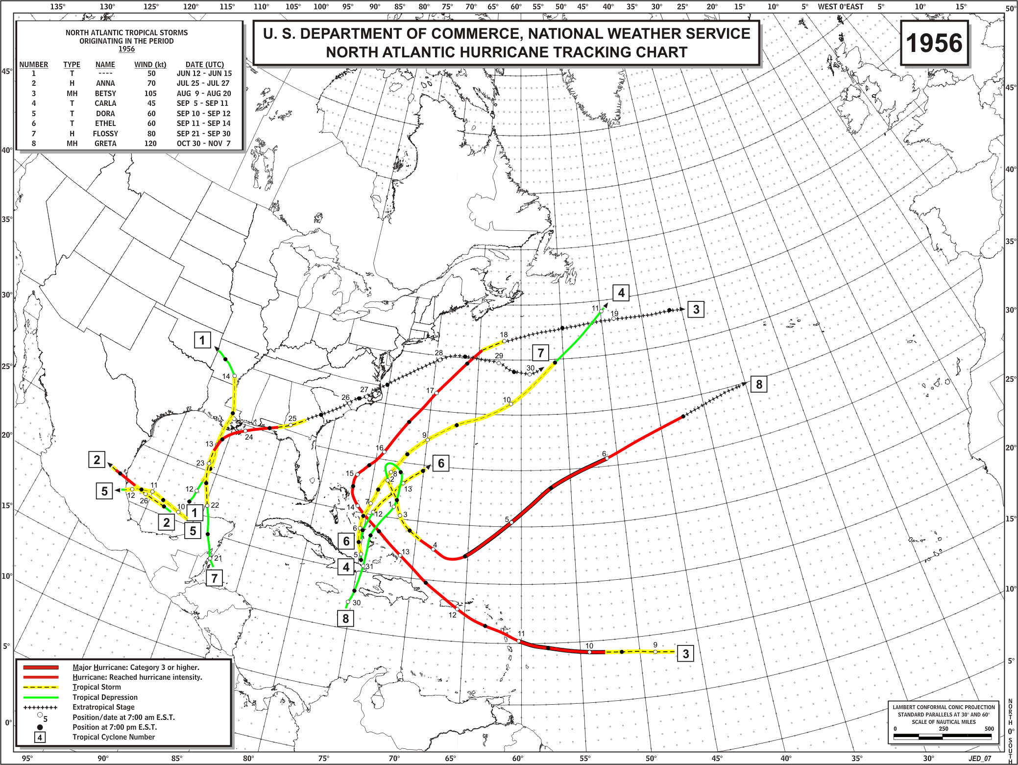
English: Track map of all storms in the 1956 Atlantic hurricane season |
| Date | |
| Source | http://www.aoml.noaa.gov/hrd/hurdat/track_maps/1956_base.gif |
| Author | Hurricane Research Division |
Laisens
This work is in the public domain in the United States because it is a work prepared by an officer or employee of the United States Government as part of that person’s official duties under the terms of Title 17, Chapter 1, Section 105 of the US Code.
Note: This only applies to original works of the Federal Government and not to the work of any individual U.S. state, territory, commonwealth, county, municipality, or any other subdivision. This template also does not apply to postage stamp designs published by the United States Postal Service since 1978. (See § 313.6(C)(1) of Compendium of U.S. Copyright Office Practices). It also does not apply to certain US coins; see The US Mint Terms of Use.
|
 | |
| This file has been identified as being free of known restrictions under copyright law, including all related and neighboring rights. | ||
Original upload log
| De/Taim | Ol sais | Yusa | Tingting |
|---|---|---|---|
| 23 Disemba 2011, 16:47:19 | 2078 × 1561 (452763 bytes) | Hurricanehink (toktok · wok) |
Ol senis bilong dispela fail
Click on a date/time to view the file as it appeared at that time.
| De/Taim | Liklik | Ol sais | Yusa | Tingting | |
|---|---|---|---|---|---|
| bilong nau | 20:18, 19 Julai 2014 | | 2,078 × 1,561 (467 KB) | GifTagger | Bot: Converting file to superior PNG file. (Source: 1956_Atlantic_hurricane_season_map.gif). This GIF was problematic due to non-greyscale color table. |
Ol fail link
There are no pages that use this file.
Global file usage
The following other wikis use this file:
- Usage on en.wikipedia.org